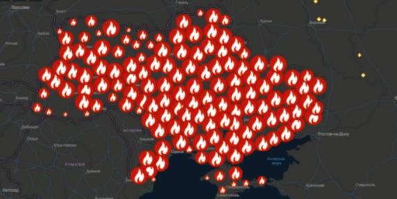
A beta-copy of the all-Ukrainian fire monitoring GIS-map has been created
Kyiv geo-analysts have created a tool to analyse fires in open ecosystems of Ukraine for the last five years, as well as to monitor fires, having broken out for the last two days.
“The all-Ukrainian GIS-map of fires in ecosystems of Ukraine for the last 5 years” has been created by the Centre for Innovation Development in cooperation with Heinrich Boell Foundation, Bureau Kyiv — Ukraine.
According to Vitaliy Selyk, the head of the project of the GIS-map development, while creating the tool, open satellite, governmental and non-governmental data were used (NASA, ESA-European Space Agency, OpenStreetMap, GeoPortalUA, StateGeoCadastre, State Emergency Service of Ukraine).

17 June 2026
Практичні рішення для розвитку мережі...
Практичні рішення для формування мережі академічних ліцеїв та впровадження реформи старшої профільної школи...
17 June 2026
У центрі відновлення мають бути люди – їхня...
15 червня 2026 року у Києві відбувся форум «Діалог з питань врядування щодо інклюзивного відновлення та розвитку», що...
17 June 2026
Президент України заснував почесну відзнаку «Громада-рятівник»
Президент України заснував почесну відзнаку...
Президент України Володимир Зеленський підписав Указ №491/2026, яким засновано почесну відзнаку «Громада-рятівник»...
17 June 2026
Фінансовий модуль АІКОМ: представлено новий інструмент для аналізу освітніх видатків
Фінансовий модуль АІКОМ: представлено новий...
15 червня відбулася презентація Фінансового модулю АІКОМ для управлінців у сфері освіти, фахівців та фахівчинь з...